
In India, the longitude of E (E) is treated as the standard meridian.
Explain Indian Standard Time (IST). How the standard time of a place is calculated?
Explain Indian Standard Time (IST). How the standard time of a place is calculated?
Important Questions on Globe : Latitudes and Longitudes
The equator is an imaginary circular line and is a very important reference point to locate places on the earth. All parallel circles from the equator up to the poles are called parallels of latitudes. Explain the important parallels of latitudes with the help of a labelled diagram.
of the earth and its climate. This is an example where geographers have used their imagination for
study and research. What does this say about human imagination? Discuss various ways in which man has
used his fertile imagination to his great advantage.
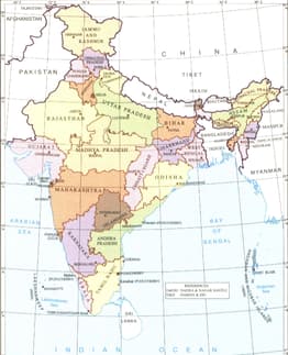
Study the map and name the important parallel which passes through the middle of our country. Name the states through which this latitude passes.
On the Outline Map of the World mark the following:
| 1. Tropic of Capricorn | 6. The Equator |
| 2. Southern Ocean | 7. The Atlantic Ocean |
| 3. Strait of Gibraltar | 8. The Indian Ocean |
| 4. Mediterranean Sea | |
| 5. Asia |
Study the map of India given below and answer the following question based on the map.
Name the states located between E and E longitudes.


